
Formation of the Alps Engelberg
Contents
The Alps are no coincidence
Anyone looking at the Titlis, Spannort, Graustock or Gross Walenstock today is seeing the result of millions of years of earth history. The mountain world around Engelberg was not created by single events, but through the interplay of seas, sediments, tectonic forces and erosion.
Today's peaks of the Uri Alps were once part of a shallow seabed. It was only the collision of Africa and Europe that formed them into the Alps as we know them today.
250 million years ago: A shallow sea
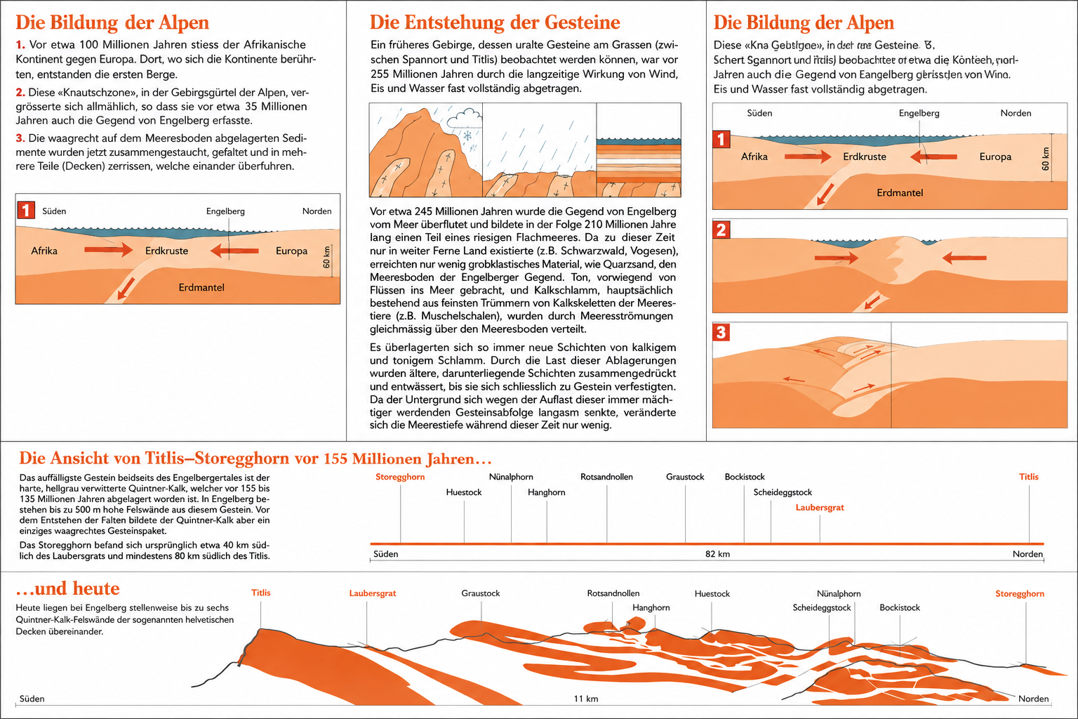
Where the peaks around Engelberg stand today, there was a shallow sea around 245 million years ago.
Rivers transported sand, clay and limestone into this basin. Over millions of years, new layers were deposited on the sea floor. Through pressure, these deposits later solidified into rock.
Many of the limestone cliffs around Engelberg originally formed from the shells and skeletons of marine animals.
The formation of the Alps
About 100 million years ago, the African continental plate began to move north.
When Africa collided with Europe, the rock layers in between were compressed, folded and thrust over one another. A mountain range gradually formed from the former seabed.
This so-called Alpine folding continues to shape the landscape of Central Switzerland to this day.
Why are the rocks vertical today?
Many layers of limestone were not only uplifted during the formation of the Alps, but also severely deformed.
Therefore, numerous folded and in places almost vertical rock strata can be found around Engelberg. This can be observed particularly impressively on the limestone faces of the Spannort, the Gross Walenstock or the peaks around the Titlis.
The Quinten limestone around Engelberg
The striking bright rock of many Engelberg peaks is so-called Quinten limestone.
This formed in the sea around 155 to 135 million years ago and today forms numerous striking rock faces in the region.
Well-known mountains made of quintin limestone include:
- Titlis
- Laubersgrat
- Graustock
- Rotsandnollen
- Huenstock
- Nünalphorn
- Scheideggstock
- Bockistock
- Storegghorn
The rock packages were displaced over large distances during the formation of the Alps.
The landscape continues to change
The Alps are not a finished mountain range. Frost, water, glaciers and gravity continue to alter the landscape to this day. Rockfalls, mudflows and erosion are constantly reshaping the mountains.
The glaciers around Titlis and Spannort also played a decisive role in shaping today's landscape during the last ice ages.
Understanding geology means understanding mountains better
Whoever knows the formation of the Alps also understands many of the special features of the mountain world around Engelberg:
- Why some rock faces drop away steeply
- Why certain peaks consist of pale limestone
- How glaciers have shaped valleys
- Where avalanche paths and rockfall zones develop
Geology is therefore not only fascinating, but also helps to read the alpine landscape better.
Further articles on mountain knowledge
- Glaciers around Engelberg
- The Ice Ages in the Urner Alps
- Flora and fauna of the alpine zone
- How avalanches form
- Geomorphology of the Alps
- History of the Engelberg Valley


