
Alpine hiking · Bannalp
Bietstöck
The distinctive shark fin above the Bannalp is climbed from the rear via steps and an exposed east ridge with a secure crack.
- Difficulty
- T5
- Time required
- about 3–4 hours
- Distance
- 8.5 km
- Ascent
- 663 hm
- Descent
- 663 hm
- Highest point
- 2’233 m
- Starting point
- Bannalp, 1’718 m
- Season
- July – October
From the Engelberg Valley Hiking Guide
The beautiful shark fin
Anyone who has been to the Bannalp will probably have noticed the Bietstöck. From the mountain station they almost fall right into your arms and it’s hard to believe that you can climb up from the back side in moderate difficulty. Over the partially exposed east ridge you reach the summit cross. The most difficult part of the climb is secured with a rope. The view is amazing! If you’re not yet tired, you can descend via the Chaiserstuel to Sinsgäuer Schonegg & return to Oberrickenbach with the two Buiräbähnli.
Step by step
Route description
Start at the Bannalp
From the mountain station, follow the trails towards Bannalper Schonegg.
On the back of the bid forms
Footprints lead to the less steep terrain behind the distinctive rock formation.
Over the eastern ridge
The partially exposed ridge requires safe footing and concentrated effort.
Secured key position
The most difficult crack point is equipped with a rope.
Return trip or extension
Downhill on the same route or long extension via Chaiserstuel and Sinsgäuer Schonegg.
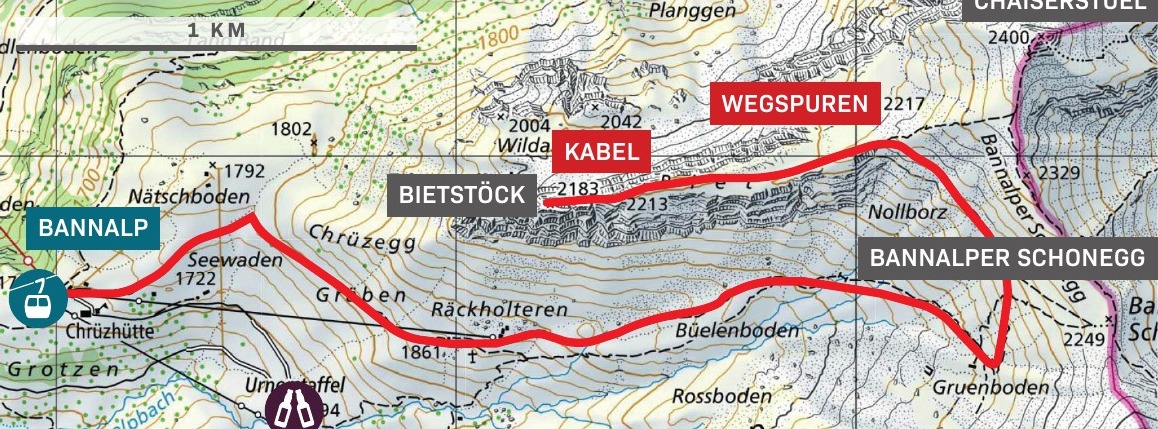
Orientation
Overview Area Oberrickenbach–Bannalp–Brändlen

Appreciate realistically
Requirements
- Comprehensive alpine experience for T5
- Very good ground stability and absolute freedom from dizziness
- Safe climbing on easy, exposed passages
- Dry, stable conditions
Good to know
Information about the tour
- The tour is significantly more challenging than the moderate terrain suggests.
- The extension over Chaiserstuel changes length and logistics significantly.
- Do not enter the east ridge in wet conditions or when visibility is uncertain.
Important: Check the weather, current trail conditions, and the operation of the required mountain railways immediately before the start.
Further goals
Similar hiking tours

Lauchernstock
A circular route through wild karst landscape to Lauchernstock, with trail markings, isolated blue markings, and a rewarding stop at the Oberfeld Alp.

Wisstritt–Sättelistock
A serious T5+-overload with rubble field, grassy slopes, steep grass slopes and climbing sections up to II – the descent takes place via the Rigidalstock climbing route.
Upper Alpe Grat
A wild T6 gem over exposed grassy slopes, couloirs, archways and rocky outcrops – unmarked and exclusively found in dry conditions.


