Not particularly good. At the end of August 2026, the Titlis Glacier is heavily ice-free: bare ice, large open crevasses and more and more rock at the edges.
An exciting insight into the terrain we ride over when freeriding on the Titlis in winter. And a good reason to take a closer look before the first powder day.
Area
Titlis / Steinberg Engelberg
Status of the report
Recordings
24 and 26 August 2026
Glacier condition
Badly melted Open columns
In focus
Freeride & pre-season
Observations by
Dani Perret IFMGA mountain guide
Snapshot from August 2026 – no current route clearance. Glacier conditions can change rapidly.
What the ice makes visible
A glacier in transition
Anyone who regularly visits the Titlis can see the changes particularly well. Areas that used to be covered in firn and snow even late in the summer now look completely different in places.
A single snapshot obviously does not replace a long-term series of measurements, but the photos from 26 August 2026 show the state of the glacier at that time quite impressively.
Amongst our winter trails
Exciting view for freeriders
For freeriders, the view of the Titlis Glacier in summer and autumn is always fascinating. Suddenly you can see what you ride over in winter with a certain lack of concern.
View of the melted Titlis glacier with the Steinberg S-variant and Bottleneck freeride lines.
The Titlis Glacier in summer, with freeride routes through the Steinberg marked on the map. The Steinberg S route and the line through the ‘Flaschenhals’ are marked. In winter, the descents take skiers across sections of the heavily crevassed glacier.
The Steinberg S-variant in summer: The marked freeride line leads across steep, glacier-covered terrain.
A view of the Steinberg S route on the Titlis once the snow has melted. The line marked on the map shows the route of the well-known freeride descent. In summer, bare ice, rock and the structure of the glacier become visible, which in winter lie hidden beneath the snow cover.
View of the melted Titlis glacier with freeride routes through the Steinberg marked. The Steinberg S variant, the bottleneck and the glacier run are highlighted. The open crevasses impressively show what terrain lies beneath the snow cover in winter.
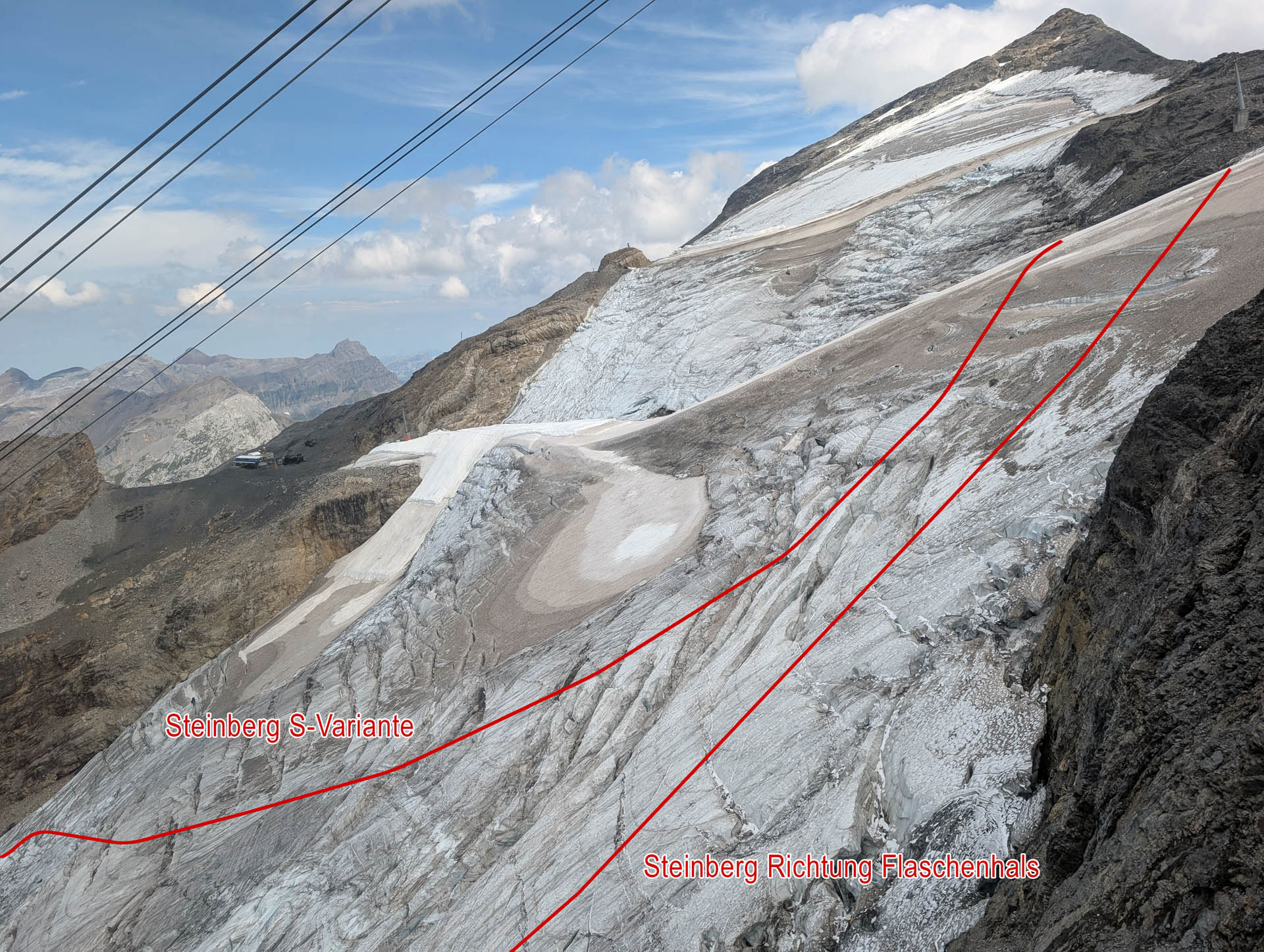
View from the new Titlis Connect cable car onto the melted Steinberg with the S-variant and the route towards the bottleneck.
A view from the Titlis Connect cable car of the Steinberg on the Titlis in late summer. Marked on the map are the well-known freeride routes: the Steinberg S variant and the route towards Flaschenhals. The significant snowmelt reveals the glacier’s structure and numerous crevasses, which lie hidden beneath the snow cover in winter.
Glacial ice on the Titlis, extensively covered with fleece. The difference in elevation compared with the surrounding ice illustrates the effect of the summer cover.
A view of the fleece cover on the Titlis Glacier in late summer. The covered glacier ice stands out clearly from the surrounding, unprotected areas and illustrates the local effect of the fleece in combating summer ice melt.
Fleece covering on Klein Titlis: The glacier ice above the glacier grotto is protected from additional melting during the summer.
A fleece cover on the glacier at Klein Titlis, above Engelberg. The cover reduces ice melt in certain areas and helps to preserve the glacier ice in the vicinity of the Titlis Glacier Grotto.
A popular route in winter, running directly beneath the Ice Flyer – in summer, the numerous crevasses become visible.
A view of the popular freeride route directly below the Ice Flyer on the Titlis. The snow-free glacier clearly reveals the numerous crevasses that are skied over in winter when there is sufficient snow cover.
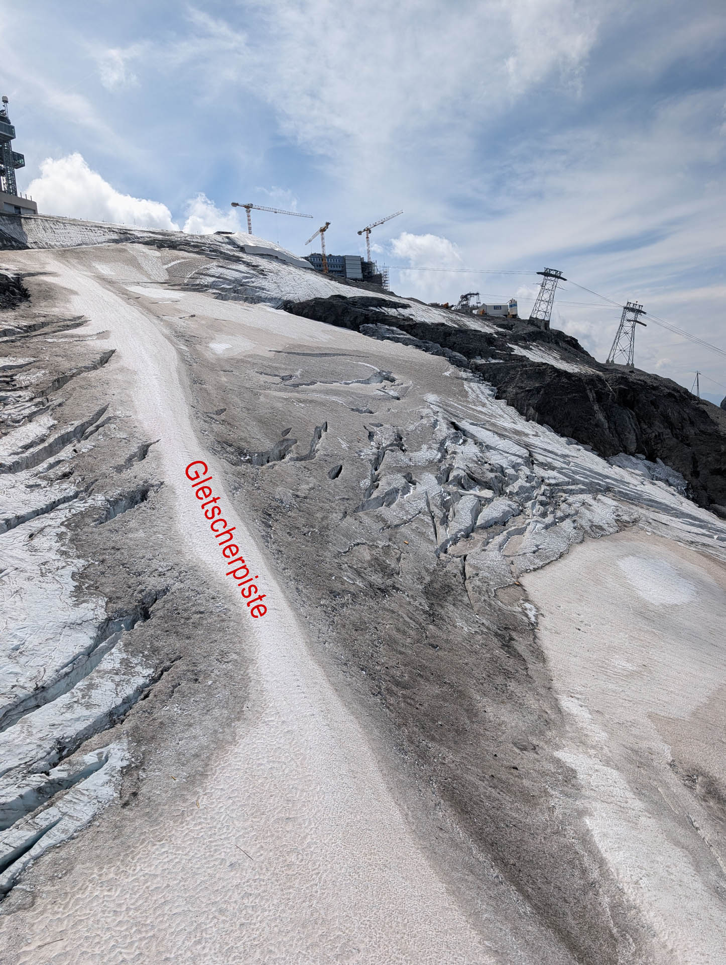
The glacier run on the Titlis in late summer – right next to it, open crevasses and heavily eroded glacier ice are visible.
View along the glacier piste on the Titlis Glacier. The photograph shows the strong contrast between the groomed or preserved piste area and the surrounding deglaciated glacier ice with numerous open crevasses.
View from the Ice Flyer of the snow-free Titlis Glacier, with exposed crevasses and the covered sections of the glacier run.
View from the Ice Flyer chairlift of the Titlis glacier in late summer. Clearly visible are open crevasses, bare ice and the areas of the glacier piste protected by fleece.
The Titlis glacier lift during the summer when it is covered with fleece. The fleece has since been removed in preparation for the coming winter season.
A view of the Titlis Glacier, which has largely lost its snow cover, in the area of the glacier lift. The photograph shows the summer fleece cover used to protect the glacier ice locally from melting. The cover has since been removed.
I wonder how deep it goes down here? One of the open crevasses in the Steinberg.
A large, open crevasse on the Steinberg on the Titlis. In late summer, the crevasses are clearly visible – in winter, one of the well-known freeride runs crosses the Titlis Glacier here.
Open gullies in the central section of the Steinberg – in winter, this is where the famous freeride run is located.
A view of the glacier, which has largely lost its snow cover, in the central section of the Steinberg on the Titlis. Open crevasses and heavily textured bare ice are clearly visible along the freeride run used in winter.
Fleece cover on the Titlis glacier is showing its effect
Clearly visible: significantly more ice remains under the fleece than on the surrounding unprotected areas.
A view across the Titlis Glacier, which has largely lost its snow cover, near the glacier lift heading towards Engelberg.
A view across the Titlis Glacier in late summer. Around the glacier lift, bare ice, shrinking patches of snow and increasingly exposed rock are clearly visible.
Fleece covering on the Titlis Glacier in the area of the glacier piste.
Non-woven fabric covers protect parts of the Titlis Glacier in the area of the glacier run and the glacier lift from direct sunlight during the summer months, thereby reducing ice melt in those areas.
A close-up of the fleece cover on the Titlis. The difference in height compared with the surrounding terrain shows just how much ice has been preserved in this area.
A fleece cover in the area of the glacier lift on the Titlis. During the summer, the white fleece reduces the amount of sunlight reaching the ice beneath it, thereby slowing down glacier melt in that specific area.
Ascent from Klein Titlis to Gross Titlis. The line shown on the map indicates the route across the terrain, which is becoming increasingly free of snow.
View from Klein Titlis of the ascent to Gross Titlis (3,238 m). The route shown on the map leads across the snow-free terrain towards the summit and reflects the current conditions at the end of August 2026.
View across the Wenden Glacier. In winter, the Titlis circular walk takes you through this impressive glaciated landscape.
View of the Wenden Glacier in the Titlis region. The glacier is crossed in winter as part of the Titlis circular walk. In late summer, the retreating snow, glacial features and surrounding rock formations are particularly clearly visible.
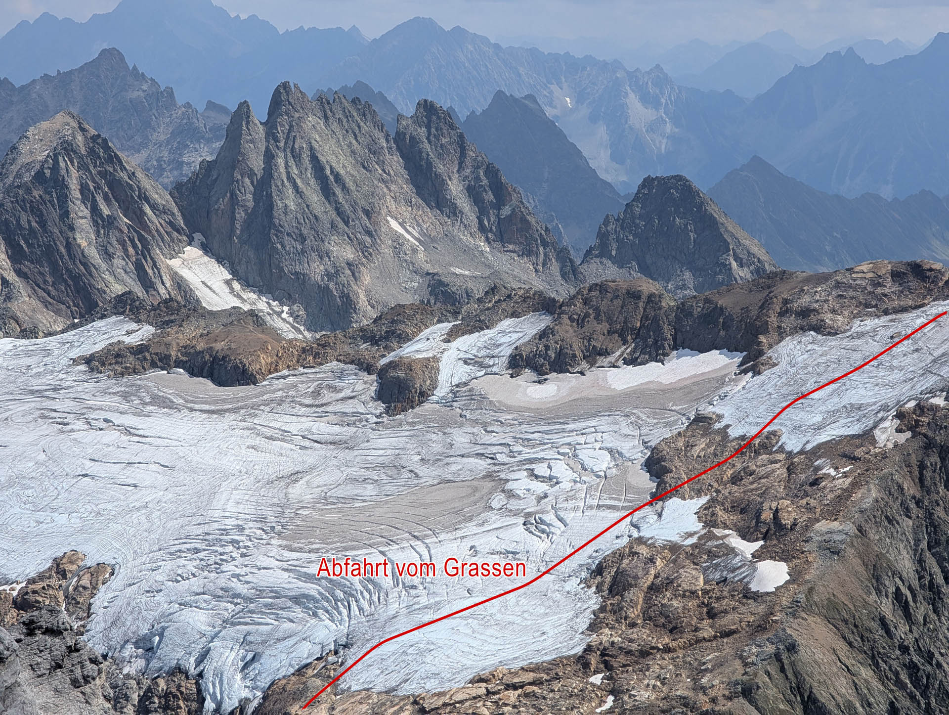
View looking south, with the descent route from the Grassen marked on the map.
View of the Grassen and the heavily melted glacier areas at the end of August.
View from Titlis towards Grassen. Clearly visible are the heavily melted glacier surfaces, bare ice, crevassed zones and large rock-free areas in late summer.
Direct descent from the Uratstock near the Fünffingerstock to the Wendengletscher – a variant occasionally used as a shortcut on the Urn Haute Route.
View of the direct descent variant from the Uratstock at the Fünffingerstock down to the Wendengletscher. The line leads through steep, glaciated terrain and, under suitable conditions, is occasionally chosen as a shortcut on the Urner Haute Route. The hanging glacier, Wendengletscher and the gap at 2789 m are marked in the image.
Hanging glacier near the Fünffingerstock with the striking rock tower known as the «Buddha».
View of the hanging glacier near the Fünffingerstock in the Susten region. Above the heavily crevassed glacial ice rises the striking rock tower known as the «Buddha».
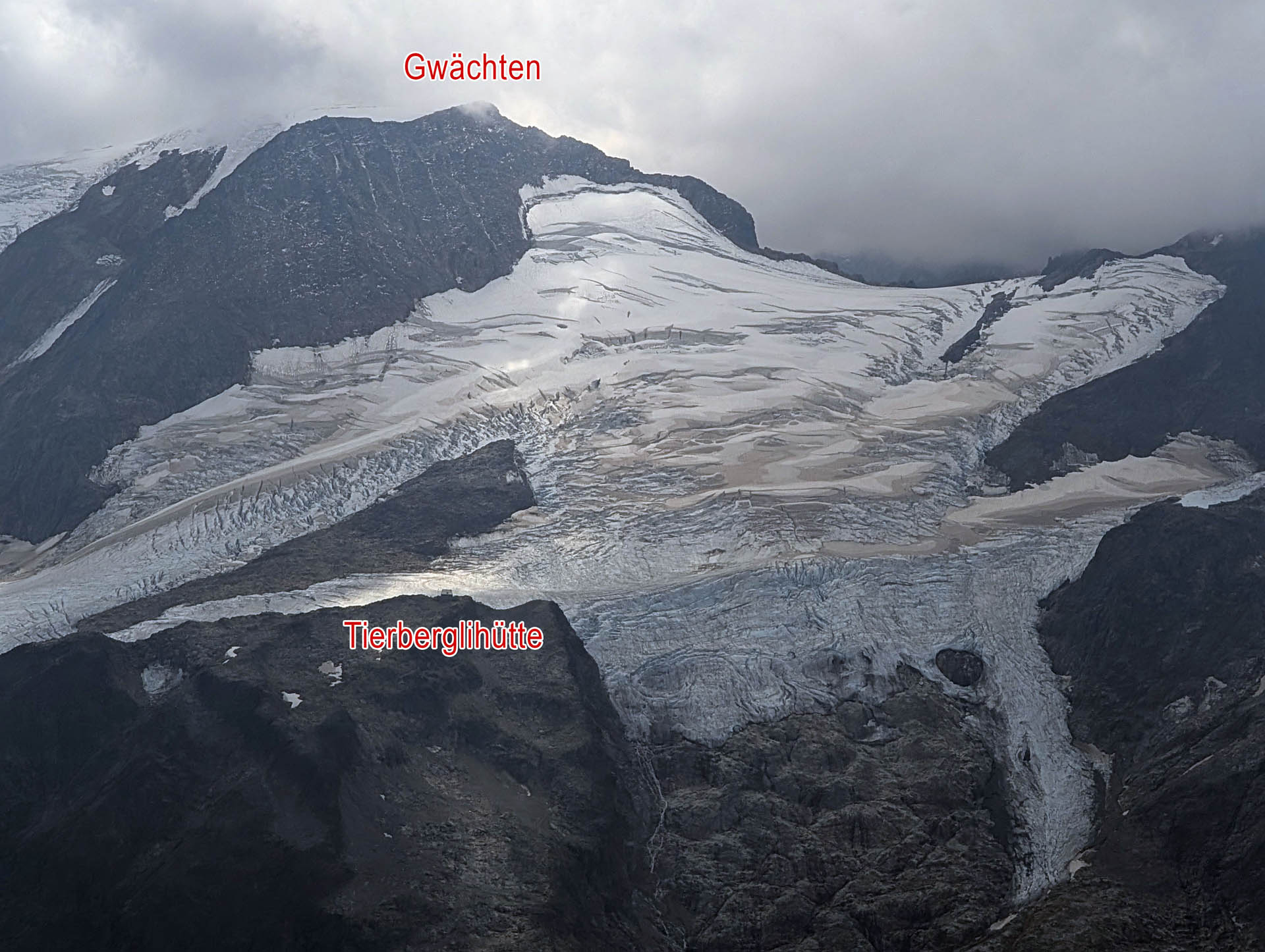
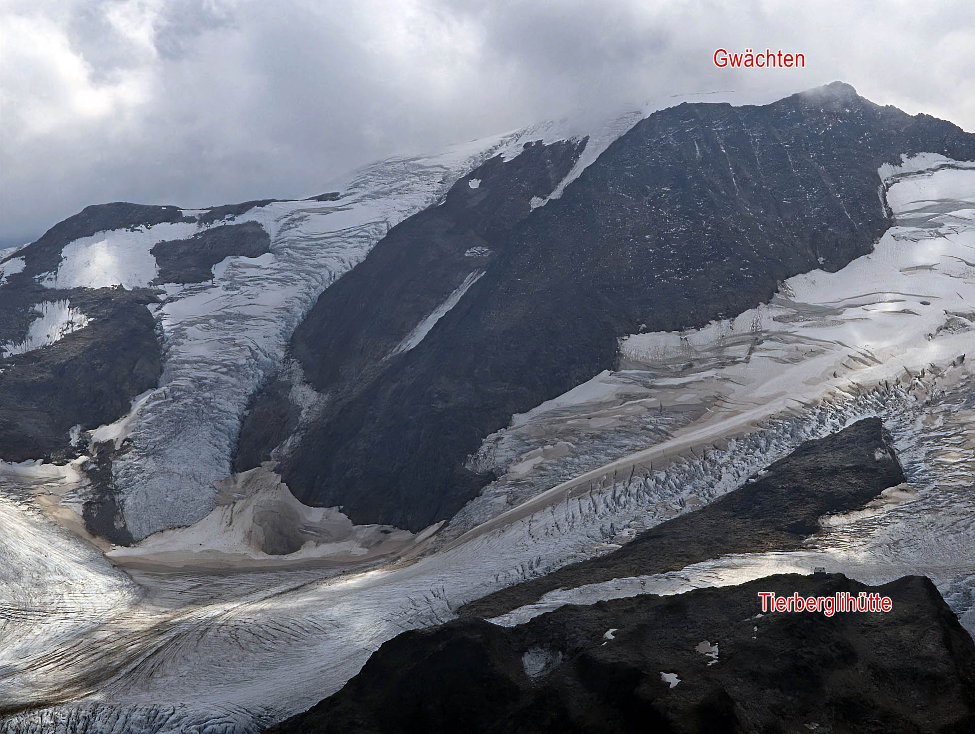
View across the heavily melted Steingletscher with the Tierberglihütte and Gwächten.
The Steingletscher in the Susten region with the Tierbergli hut and Gwächten. Clearly visible are the heavy snow melt, large crevasse zones and the structure of the glacier in late summer.
View of the de-glaciated Stein Glacier with cornices and the Tierbergli hut in the Susten region.
View of the Steingletscher in the Susten region with clearly visible bare ice, crevasses and snow-free areas. Marked in the image are the cornices and the Tierberglihütte.
View of the heavily melted glacier areas between Sustenhorn, Sustenlimi and the Tierberglihütte.
Glacier landscape in the Susten region between Sustenhorn, Sustenlimi and the Tierbergli hut. In late summer, bare ice, pronounced crevasse zones and the structure of the heavily melted glacier are particularly clearly visible.
Recordings from 24 and 26 August 2026. Drawn lines are for illustrative purposes and do not indicate current passability.
White is not necessarily load-bearing
The delicate phase of the pre-season
Many of the crevasses are large and open at the end of August. In high winter, snowfall and wind-drifted snow can fill crevasses or cover them with thick snow bridges. However, whether these will bear weight depends on the actual conditions.
More interesting – and more delicate – is the pre-season. As soon as the first heavier snowfalls arrive, the picture on the glacier changes very quickly. Crevasses that are still clearly open in summer can suddenly become barely visible.
And typically, it is precisely during this phase that the first freeriders are already carving their tracks through the Steinberg.
The first snow is only the beginning
Take a closer look at this early winter
How the situation will actually look this coming winter cannot, of course, be said at the end of August. Decisive will be how much snow falls in the coming months and what the wind makes of it.
Following the extensive snow melt, it is especially worthwhile closely monitoring developments this early winter. It is not the white surface that is decisive, but rather how thick and stable the snowpack over the crevasses has actually become.
Lots of work. Often invisible.
A big thank you to the Titlis piste team
Incidentally, these pictures also give you an idea of the sort of terrain you’ll be tackling on the Titlis.
Therefore, a big thank you at this point to the patrollers of the Titlis piste team. They do a tremendous job in preparing, securing and maintaining the ski slopes in winter. As a skier, you don't notice most of it at all.
Brilliant, what goes on behind the scenes is fantastic – cheers!
Do you want to get ready for the coming winter and not only start thinking about how it all works again on the first powder day?
Our pre-season camps in Engelberg are all about exactly that: refreshing your knowledge, learning new things and applying as much of it as possible out on the mountain.
We're taking that out into the field
Skiing techniques in off-piste terrain and deep snow – ski more efficiently, safely and with more fun off-piste
Glaciers and crevasses
Route selection on the glacier
Crevice rescue and self-ascent
Avalanche prevention and route planning
Avalanche transceivers, probing and efficient shovelling
Line choice in freeride terrain
Group tactics and the human factor
Snowpack structure and assessment
Rope handling, knots and abseiling
Improvised rescue methods and trouble-shooting in the mountains
This is not just about theory: Skiing and personal skiing technique are an important part of the camps. For good technical ability creates reserves – especially when the snow and terrain become more demanding.
If you want to be safer, more independent and more skilled in freeride and ski touring terrain this coming winter: join us at the Pre-Season Camp in Engelberg.
More about glaciers & high-altitude mountaineering
How are the glaciers around Engelberg changing, and what does that mean for your next high-altitude tour? Here you will find further insights and suitable offers.
The Titlis Glacier above Engelberg is heavily melted out at the end of August 2026. Current pictures show bare glacier ice, large open crevasses and more and more rock emerging at the edges. A fascinating insight into the terrain we ski over when freeriding on the Titlis in winter.
Anyone who regularly visits the Titlis can see the changes particularly well. Areas that used to be covered in firn and snow even late in the summer now look completely different in places.
A single snapshot obviously does not replace a long-term series of measurements. The pictures from 26 August 2026 show quite impressively the current state of the glacier.
And they show something else: what lies beneath our blanket of snow in winter.
Exciting view for freeriders
For freeriders, the view of the Titlis Glacier in summer and autumn is always fascinating. Suddenly you can see what you ride over in winter with a certain lack of concern.
View of the melted Titlis glacier with the Steinberg S-variant and Bottleneck freeride lines.
The Titlis Glacier in summer, with freeride routes through the Steinberg marked on the map. The Steinberg S route and the line through the ‘Flaschenhals’ are marked. In winter, the descents take skiers across sections of the heavily crevassed glacier.
The Steinberg S-variant in summer: The marked freeride line leads across steep, glacier-covered terrain.
A view of the Steinberg S route on the Titlis once the snow has melted. The line marked on the map shows the route of the well-known freeride descent. In summer, bare ice, rock and the structure of the glacier become visible, which in winter lie hidden beneath the snow cover.
View of the melted Titlis glacier with freeride routes through the Steinberg marked. The Steinberg S variant, the bottleneck and the glacier run are highlighted. The open crevasses impressively show what terrain lies beneath the snow cover in winter.
View from the new Titlis Connect cable car onto the melted Steinberg with the S-variant and the route towards the bottleneck.
A view from the Titlis Connect cable car of the Steinberg on the Titlis in late summer. Marked on the map are the well-known freeride routes: the Steinberg S variant and the route towards Flaschenhals. The significant snowmelt reveals the glacier’s structure and numerous crevasses, which lie hidden beneath the snow cover in winter.
Glacial ice on the Titlis, extensively covered with fleece. The difference in elevation compared with the surrounding ice illustrates the effect of the summer cover.
A view of the fleece cover on the Titlis Glacier in late summer. The covered glacier ice stands out clearly from the surrounding, unprotected areas and illustrates the local effect of the fleece in combating summer ice melt.
Fleece covering on Klein Titlis: The glacier ice above the glacier grotto is protected from additional melting during the summer.
A fleece cover on the glacier at Klein Titlis, above Engelberg. The cover reduces ice melt in certain areas and helps to preserve the glacier ice in the vicinity of the Titlis Glacier Grotto.
A popular route in winter, running directly beneath the Ice Flyer – in summer, the numerous crevasses become visible.
A view of the popular freeride route directly below the Ice Flyer on the Titlis. The snow-free glacier clearly reveals the numerous crevasses that are skied over in winter when there is sufficient snow cover.
The glacier run on the Titlis in late summer – right next to it, open crevasses and heavily eroded glacier ice are visible.
View along the glacier piste on the Titlis Glacier. The photograph shows the strong contrast between the groomed or preserved piste area and the surrounding deglaciated glacier ice with numerous open crevasses.
View from the Ice Flyer of the snow-free Titlis Glacier, with exposed crevasses and the covered sections of the glacier run.
View from the Ice Flyer chairlift of the Titlis glacier in late summer. Clearly visible are open crevasses, bare ice and the areas of the glacier piste protected by fleece.
The Titlis glacier lift during the summer when it is covered with fleece. The fleece has since been removed in preparation for the coming winter season.
A view of the Titlis Glacier, which has largely lost its snow cover, in the area of the glacier lift. The photograph shows the summer fleece cover used to protect the glacier ice locally from melting. The cover has since been removed.
I wonder how deep it goes down here? One of the open crevasses in the Steinberg.
A large, open crevasse on the Steinberg on the Titlis. In late summer, the crevasses are clearly visible – in winter, one of the well-known freeride runs crosses the Titlis Glacier here.
Open gullies in the central section of the Steinberg – in winter, this is where the famous freeride run is located.
A view of the glacier, which has largely lost its snow cover, in the central section of the Steinberg on the Titlis. Open crevasses and heavily textured bare ice are clearly visible along the freeride run used in winter.
Fleece cover on the Titlis glacier is showing its effect
Clearly visible: significantly more ice remains under the fleece than on the surrounding unprotected areas.
A view across the Titlis Glacier, which has largely lost its snow cover, near the glacier lift heading towards Engelberg.
A view across the Titlis Glacier in late summer. Around the glacier lift, bare ice, shrinking patches of snow and increasingly exposed rock are clearly visible.
Fleece covering on the Titlis Glacier in the area of the glacier piste.
Non-woven fabric covers protect parts of the Titlis Glacier in the area of the glacier run and the glacier lift from direct sunlight during the summer months, thereby reducing ice melt in those areas.
A close-up of the fleece cover on the Titlis. The difference in height compared with the surrounding terrain shows just how much ice has been preserved in this area.
A fleece cover in the area of the glacier lift on the Titlis. During the summer, the white fleece reduces the amount of sunlight reaching the ice beneath it, thereby slowing down glacier melt in that specific area.
Ascent from Klein Titlis to Gross Titlis. The line shown on the map indicates the route across the terrain, which is becoming increasingly free of snow.
View from Klein Titlis of the ascent to Gross Titlis (3,238 m). The route shown on the map leads across the snow-free terrain towards the summit and reflects the current conditions at the end of August 2026.
View across the Wenden Glacier. In winter, the Titlis circular walk takes you through this impressive glaciated landscape.
View of the Wenden Glacier in the Titlis region. The glacier is crossed in winter as part of the Titlis circular walk. In late summer, the retreating snow, glacial features and surrounding rock formations are particularly clearly visible.
View looking south, with the descent route from the Grassen marked on the map.
View of the Grassen and the heavily melted glacier areas at the end of August.
View from Titlis towards Grassen. Clearly visible are the heavily melted glacier surfaces, bare ice, crevassed zones and large rock-free areas in late summer.
Direct descent from the Uratstock near the Fünffingerstock to the Wendengletscher – a variant occasionally used as a shortcut on the Urn Haute Route.
View of the direct descent variant from the Uratstock at the Fünffingerstock down to the Wendengletscher. The line leads through steep, glaciated terrain and, under suitable conditions, is occasionally chosen as a shortcut on the Urner Haute Route. The hanging glacier, Wendengletscher and the gap at 2789 m are marked in the image.
Hanging glacier near the Fünffingerstock with the striking rock tower known as the «Buddha».
View of the hanging glacier near the Fünffingerstock in the Susten region. Above the heavily crevassed glacial ice rises the striking rock tower known as the «Buddha».
View across the heavily melted Steingletscher with the Tierberglihütte and Gwächten.
The Steingletscher in the Susten region with the Tierbergli hut and Gwächten. Clearly visible are the heavy snow melt, large crevasse zones and the structure of the glacier in late summer.
View of the de-glaciated Stein Glacier with cornices and the Tierbergli hut in the Susten region.
View of the Steingletscher in the Susten region with clearly visible bare ice, crevasses and snow-free areas. Marked in the image are the cornices and the Tierberglihütte.
View of the heavily melted glacier areas between Sustenhorn, Sustenlimi and the Tierberglihütte.
Glacier landscape in the Susten region between Sustenhorn, Sustenlimi and the Tierbergli hut. In late summer, bare ice, pronounced crevasse zones and the structure of the heavily melted glacier are particularly clearly visible.
Many of the crevasses are now large and open. In the dead of winter, with good snow cover, this is usually much less problematic. With snowfall and wind transport, many crevasses are filled in or covered by thick and stable snow bridges.
The pre-season is more interesting – and more delicate.
As soon as the first heavy snowfalls arrive, the scenery on the glacier changes very quickly. Crevasses that are still clearly open in summer can suddenly become barely visible.
However: Just because it’s covered in snow doesn’t mean it’s safe to walk on.
Especially at the beginning of winter, thin snow bridges can form over open crevasses. From above, the glacier then already looks nicely wintry, while large voids are still present underneath.
And typically, it is precisely during this phase that the first freeriders are already carving their tracks through the Steinberg.
Take a closer look at this early winter
Of course, at the end of August it is still impossible to say what the situation will actually be like this coming winter.
The crucial point is, how much snow will fall in the coming months and what the wind will do with it.
Following the extensive snow melt, it is especially worthwhile closely monitoring developments this early winter. It is not the white surface that is decisive, but rather how thick and stable the snowpack over the crevasses has actually become.
That is why the summer photos are also of interest in winter. They show quite impressively, what lies beneath the snow cover that will eventually form on the Steinberg.
A big thank you to the Titlis piste team
Incidentally, these pictures also give you an idea of the sort of terrain you’ll be tackling on the Titlis.
So, at this point, a big thank you to the Patrol officers from the Titlis Slope Team. You are doing a tremendous job in preparing, securing and maintaining the ski slopes in winter.
As a skier, you don't notice much of that at all.
Brilliant, what goes on behind the scenes is fantastic – cheers!
Area: Titlis / Steinberg, Engelberg Photographs: 24 and 26 August 2026
Do you want to get ready for the coming winter and not only start thinking about how it all works again on the first powder day?
At our Pre-season camps in Engelberg this is precisely what it is about: refreshing knowledge, learning new things and applying as much of it as possible out in the field.
Among other things, we deal with:
Skiing techniques in off-piste terrain and deep snow – ski more efficiently, safely and with more fun off-piste
Glaciers and crevasses
Route selection on the glacier
Crevice rescue and self-ascent
Avalanche prevention and route planning
Avalanche transceivers, probing and efficient shovelling
Line choice in freeride terrain
Group tactics and the human factor
Snowpack structure and assessment
Rope handling, knots and abseiling
improvised rescue methods and trouble-shooting in the mountains
This is not just about theory: Skiing and personal skiing technique are an important part of the camps. For good technical ability creates reserves – especially when the snow and terrain become more demanding.
If you want to be safer, more independent and more skilled in freeride and ski touring terrain this coming winter: join us at the Pre-Season Camp in Engelberg.