Border dispute at Titlis
At Titlis, for centuries, the monastery of Engelberg and Nidwalden fought over boundaries and usage rights. Contracts from 1435 and 1686, maps from the late 17th century, and boundary signs from 1845 testify to this. Particularly revealing is a misaligned mountain name on a map.
Grass is more valuable than the view
A map is meant to end a dispute. On the Titlis, it initially helps to prolong it. On a historical map, even a mountain name is recolored and placed in a different place.
Behind this lies a question with tangible consequences: Where does the territory of the monastery of Engelberg end, and where does Nidwalden begin?
Today, a boundary between rock and glacier appears as an abstract line. For those involved at the time, it is about pastures, usage rights, and control. Who has control over an area also determines who is allowed to work there.
The conflicts date back far. As early as 1435 attempts were made to regulate the situation. However, old place names cannot always be clearly applied to the terrain. A mountain name can refer to a peak, a flank, or a larger area of terrain. What sounds binding in the contract remains open to interpretation.
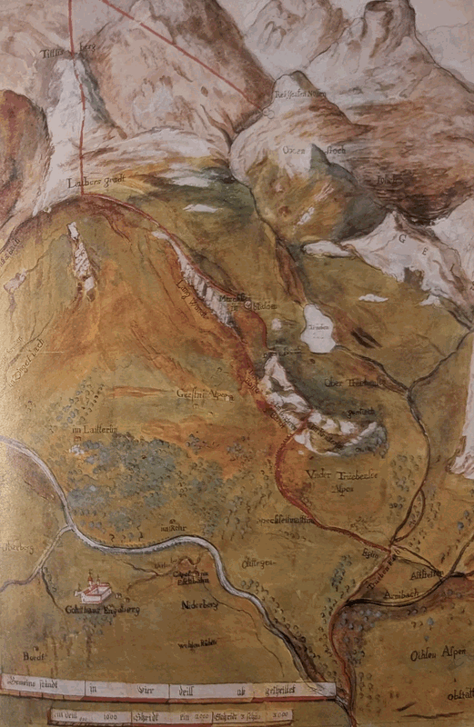
A new treaty of 1686 is intended to create clarity. Two years later, Mathias Reytz produces a map. Several copies serve as a basis for the parties involved. However, the mapwork does not lead to a common interpretation.
A shifted name
The historian Rolf De Kegel describes in his chapter on border history a remarkable finding: Under ultraviolet light, a painted inscription becomes visible on the Engelberg map presentation. The name «Titlis Berg» has been moved.
This is more than just a cartographic curiosity. When a contract refers to a specific mountain, its position on the map changes the interpretation of a boundary. The drawing itself becomes an argument.
The dispute sometimes leads to economic countermeasures. The conflict therefore by no means remains confined to the mountains. It affects relationships, trade, and everyday life in the valley.
The border must be moved to the ground
As early as the 19th century, investigation commissions were investigating the course of events. In 1844, an expedition led by Maurus Feierabend entered the disputed area. In 1845, boundary markers were carved into the rock.
The long history shows how much work is behind a seemingly simple line. Written agreements, local knowledge, and surveying all have to come together. At Titlis, political history can therefore also be read: Who names and marks a mountain determines how others understand it.
Frequently asked questions
Why was there a border dispute on Titlis?
The monastery of Engelberg and Nidwalden disputed the spatial boundaries of their territories and the associated usage rights. Unclear place names made it difficult to interpret old contracts.
What role did the historical map play?
It was intended to make the border clearer. On an Engelberg version, the name Titlis Berg was changed. Rolf De Kegel describes how an older inscription could be read again under ultraviolet light.
When was the boundary marked on the ground?
After investigations and an expedition in 1844, border markers were struck into the rock in 1845.
Was it just about the summit of Titlis?
No. The dispute concerned a larger mountain range with meadows, rock and glaciers. Behind the map lines were economic interests and rights of dominion.
Sources and classification
Text base: Rolf De Kegel: Der Grenz-Berg, pp. 26–39. In: Daniel Anker (ed.), Titlis – Switzerland’s playground, AS Verlag, Zürich, 2001. Additional sources are linked below.
Editorial: Dani Perret, mountain guide in Engelberg. Historical information; no current route description.
More from the mountains
History, tours and local mountain knowledge around Engelberg and Titlis.