Hiking · Hahnen
Zieblenspitz 1’909 m
A distinctive round tour from Horbis with a steep final climb and unobstructed views of Engelberg.
- Difficulty
- T3
- Time required
- about 4 hours
- Distance
- 9.5 km
- Ascent
- 890 hm
- Descent
- 890 hm
- Highest point
- 1’909 m
- Starting point
- Horbis / The End of the World
- Season
- June – October
From the Engelberg Valley Hiking Guide
The magical triangle
The distinctive triangle is very visible from the village. The hike to the «Zieblen Spitz» is a rewarding tour, where you will be rewarded with great views.
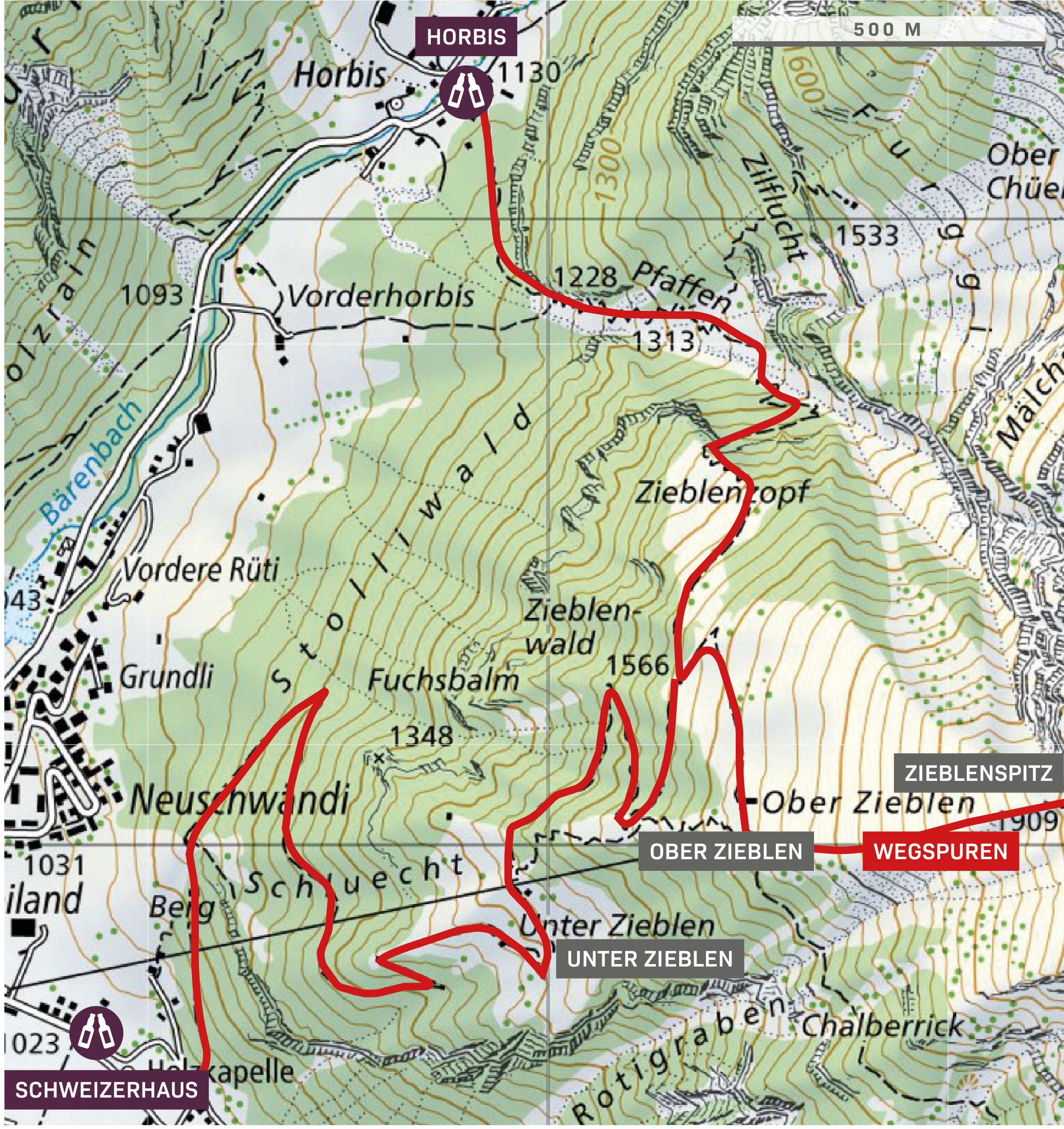
The best way to start is at Horbis (Ende der Welt) and hike the beautiful path over the Zieblenzopf to Alp Zieblen. The last stretch up to the triangle is steep and there are only trail markings. The descent is best done directly over Unter Zieblen to the Schweizerhaus or, for Fitte, further into the Fürenalp.
Step by step
Route description
Start in Horbis
The path from «the end of the world» leads through the heather-covered ridge towards Alp Zieblen.
About Ober Zieblen
The mountain path gradually gains altitude and opens up views over the Engelberg Valley.
Steep up to the triangle
The last stretch to Zieblenspitz is steep. In some places there are only traces of the path.
Descent via Unter Zieblen
Directly after Unter Zieblen, you return to the Swiss House. Physically fit hikers can continue to Fürenalp.
Appreciate realistically
Requirements
- Good footing for the steep mountain slope
- Safe walking on weak paths
- Adequate fitness for around 890 meters of elevation gain
- Dry conditions
Good to know
Information about the tour
- The final rise appears harmless from the valley, as it really is.
- In wet conditions, the steep grassy and rocky passages are treacherous.
- The extension to the Fürenalp makes the round a significantly longer tour.
Important: Times, difficulties, and road conditions may change. Check current weather, train, hut, and trail information before starting.
Further goals
Similar hiking tours in the Hahnen area

Hahnen 2’606 m
The landmark of Engelberg as a challenging alpine summit hike.

Panorama road Horbis–Fürenalp
From Horbis via Ober Zieblen and the Alp Tagenstall to the Fürenalp – one of the most beautiful mountain hikes in the valley.

Wissigstock 2’886 m
An exciting summit above the Griessengletscher – as a hike from the Rugghubelhütte.
Mountain trails · Trailrunning · HOT
Zieblenspitz as a trail run
The distinctive triangle above Engelberg is a beautiful destination for a steep mountain run. Follow the mountain path to Alp Zieblen. At the summit, paths change direction, with steep grass and rocky steps.
Running characteristics and classification
- Climb from Horbis over Zieblenzopf to Alp Zieblen and divide the ascent evenly.
- Finally, reduce the speed significantly. The summit slope requires safe footing and dry ground.
- For the return journey, choose the described route via Unter Zieblen or turn back on the familiar route.
Questions about the running variant
Is the tick-borne disease comparable to the plague?
No. The Hahnen is significantly higher and technically much more demanding. The Zieblenspitz remains a steep mountain destination, where good running training does not replace the ability to walk confidently.
Are the walking times also running times?
The time specifications in the tour description are not personal running times. In trail running, they depend especially on experience, running volume, conditions, and breaks. Technical difficulties remain unchanged.